
Watching a drone glide above the Everest region and capture endless Himalayan peaks, deep valleys and winding trekking trails can easily make you wonder, “Can I fly a drone over Mount Everest too?” It is a common question among trekkers and photographers planning an Everest adventure.
The possibilities sound incredible, but flying a drone in the Everest region is not as simple as packing one in your backpack and launching it whenever you find the perfect view. Nepal has specific drone regulations, and additional restrictions apply around Everest Base Camp, Sagarmatha National Park and Mount Everest itself.
Mount Everest is one of the most spectacular places on Earth to photograph. Towering Himalayan peaks, the Khumbu Glacier, colourful settlements, prayer flags and the dramatic landscape surrounding Everest Base Camp make it easy to understand why travellers want to capture the region from the air.
So, can you fly a drone over Mount Everest?
The simple answer is: you cannot casually fly a drone around Mount Everest or Everest Base Camp as an ordinary tourist. Drone flights are possible in certain circumstances, but they require permission from the relevant authorities. Mount Everest lies inside Sagarmatha National Park, meaning additional protected-area regulations apply in addition to Nepal's general aviation rules.
This means carrying a drone on an Everest Base Camp trek does not automatically give you permission to launch it. Even a small recreational drone may require registration and approvals before it can be operated legally.
In this guide, we explain the drone rules for Mount Everest, the permits required for Everest Base Camp, why the regulations are strict, what happens when drones are operated without permission, and how professional drones are currently being used on Everest.
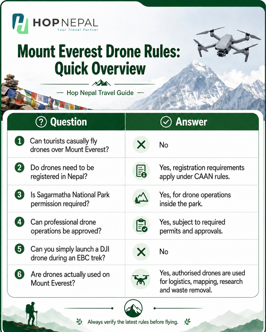
Mount Everest Drone Rules: Quick Overview
Nepal's drone rules are primarily overseen by the Civil Aviation Authority of Nepal (CAAN), with other government and local authorities involved depending on the location and purpose of the flight.
Are Drones Allowed in Nepal?
Yes. Drones are not completely banned in Nepal, but their operation is regulated.
The Civil Aviation Authority of Nepal regulates unmanned aircraft operations, while Nepal's Ministry of Home Affairs also provides procedures governing drone use.
CAAN classifies drones according to their maximum take-off weight: 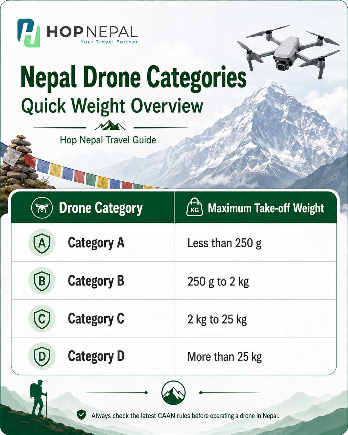
These classifications matter because the level of risk and regulatory requirements generally increase with the aircraft's size, weight, and intended use.
Foreign travellers should also be aware that CAAN provides a temporary drone registration process requiring documentation such as a valid passport and Nepal entry visa, together with information about the intended drone operation.
However, CAAN registration alone does not give you permission to fly anywhere you choose. This distinction becomes particularly important in the Everest region.
Can You Fly a Drone at Everest Base Camp?
For an ordinary trekker, the practical answer is no, not without prior permission.
Everest Base Camp and much of the popular Everest trekking region fall within Sagarmatha National Park. The park contains Mount Everest and other important Himalayan landscapes, and drone flights within the protected area require specific approval.
According to the official Sagarmatha National Park website, anyone seeking to operate a drone within the park must follow a process involving:
- Registration of the drone with the Civil Aviation Authority of Nepal (CAAN).
- Approval from the Department of National Parks and Wildlife Conservation (DNPWC) in Kathmandu.
- Approval from the District Administration Office in Salleri, Solukhumbu.
- Final permission from Sagarmatha National Park, based on the relevant approvals.
Additional requirements may apply depending on the purpose, flight location, aircraft category, filming activity, or security considerations. Therefore, seeing someone flying a drone along the Everest Base Camp trail does not mean tourists are generally free to do the same.
Why Are Drone Regulations Around Mount Everest So Strict?
At first, the restrictions can appear excessive. After all, the Everest region is surrounded by huge mountains and apparently empty skies. In reality, the airspace and environment are much more complicated.
Mount Everest Lies Inside Sagarmatha National Park
Mount Everest is located within Sagarmatha National Park, a protected Himalayan landscape established in 1976. The park contains glaciers, high mountains, valleys, settlements and ecologically important habitats.
Allowing unrestricted recreational drone flights could create unnecessary noise and disturbance in a conservation area. This is one of the differences between flying a drone in an ordinary open landscape and operating one around Everest.
Aircraft Safety Is Extremely Important
The Everest region has active aviation operations. Lukla serves as the main aviation gateway for many Everest trekkers, while helicopters operate throughout the Khumbu for rescue, transport and expedition support.
An unexpected drone can become an aviation hazard if it enters an area where helicopters or other aircraft are operating. For this reason, drone pilots should never assume that a remote-looking Himalayan valley means there is no aircraft traffic.
The Nepal government’s drone procedures are intended, in part, to keep unmanned aircraft operations aligned with broader aviation safety requirements.
The Everest Region Is Environmentally Sensitive
The Everest region receives trekkers, climbers, expedition teams, porters and other visitors every year. Despite its vast appearance, its high-altitude environment is sensitive to human disturbance.
Sagarmatha National Park manages the area not simply as a tourist destination but as a protected natural landscape. Requiring permission for drones helps authorities control how and where aerial activities take place.
Local Communities and Religious Sites Deserve Privacy and Respect
A trip through the Everest region is not simply a journey through mountains.
Villages, monasteries, stupas, mani walls and other religious sites are part of the cultural landscape of Khumbu. Even when an aerial photograph appears harmless, continuously flying a camera-equipped drone over settlements or religious sites can disturb residents and visitors.
Legal permission, therefore, should not be treated as the only consideration. Responsible drone operation also involves respecting people's privacy, local customs and the atmosphere of sacred places.
What Permits Do You Need to Fly a Drone Around Everest?
There is no single "Everest drone permit" that automatically takes care of everything. The exact requirements depend on the aircraft, purpose and proposed operating area.
For operations inside Sagarmatha National Park, the park itself identifies the main approval chain as CAAN registration - DNPWC approval - Solukhumbu District Administration Office approval - Sagarmatha National Park permission.
Professional filming, research, mapping or other specialised operations may involve additional documentation and coordination. This is why travellers planning drone photography around Everest should start the process well before arriving in Lukla or beginning their trek.
Do not expect to reach Everest Base Camp and obtain permission from a checkpoint simply by asking.
Can You Fly a Drone Over the Summit of Mount Everest?
This is very different from flying a few metres above a trekking trail.
Mount Everest reaches 8,848.86 metres above sea level, creating some of the most demanding conditions in which an unmanned aircraft could operate. DJI has demonstrated specialised high-altitude drone operations on Everest, including flights reaching the summit area, but these have been organised technical operations rather than ordinary tourist flights.
Flying near the summit presents significant challenges involving:
- extremely thin air
- powerful and unpredictable winds
- freezing temperatures
- reduced battery performance
- difficult navigation
- limited opportunities for emergency landing
- communication and signal challenges
- aviation and legal restrictions
Although drones have flown extremely high on Everest, this should not be confused with a recreational visitor being permitted to launch a consumer drone from Everest Base Camp.
Why Is Flying a Drone at Everest Base Camp Technically Difficult?
Even with official permission, flying a drone in the Everest region is considerably harder than flying one at lower elevations. Everest Base Camp itself sits more than 5,000 metres above sea level. At such elevations, air density is significantly lower.
A drone produces lift by moving air through its propellers. In thinner air, the motors and propellers have to work harder to generate enough lift and maintain stable flight. Cold creates another problem.
Lithium batteries perform less efficiently in very low temperatures, potentially reducing usable flight time. Strong Himalayan winds can further increase power consumption and make a drone more difficult to control. Professional equipment used on Everest is therefore tested specifically for extreme altitude and temperature.
For example, DJI's FlyCart series has undergone dedicated high-altitude testing rather than simply being taken to Everest and flown under normal settings.
Drones Are Already Being Used on Mount Everest
The interesting part of the story is that while recreational drone flying remains tightly controlled, drones are becoming increasingly valuable tools on Everest. Their purpose now extends far beyond photography.
Drone Deliveries Between Everest Base Camp and Camp I
In 2024, DJI and Nepalese drone company Airlift Technology conducted high-altitude cargo-drone tests on the Nepal side of Everest.
The FlyCart 30 transported supplies from Everest Base Camp towards Camp I and carried waste on its return journey. The operation demonstrated how drones could reduce the number of dangerous journeys people need to make through the Khumbu Icefall.
Everest Drone Operations Expanded in 2026
The technology has developed considerably since those initial tests.
During the 2026 spring climbing season, DJI reported using the FlyCart 100 with Nepalese partner Airlift to transport equipment and waste between Everest Base Camp and Camp I.
According to DJI, the operation moved a combined 10,073 kg, including 7,215 kg of expedition supplies going upwards and 2,858 kg of waste coming down. High-altitude mapping was also carried out using another drone over areas of the Khumbu Icefall.
These operations show an important distinction:
Drones themselves are not banned from Everest. Unauthorised drone flying is the issue. Professionally approved operations can support conservation, expedition logistics, research and mountain safety.
How Drones Could Change Everest Expeditions
The future role of drones on Everest could be much more important than capturing dramatic social media footage.
Current projects suggest several practical applications.
Waste Removal
Carrying waste down from higher camps is physically difficult and dangerous. Cargo drones could reduce the time workers spend travelling through hazardous sections of the mountain.
Expedition Supplies
Oxygen cylinders, ropes, ladders and other equipment traditionally require significant human effort to transport through dangerous terrain. Authorised cargo drones can supplement this work on suitable routes.
Glacier Mapping
Drone mapping can provide detailed information about changing ice formations, crevasses and hazardous sections of routes. During the 2026 Everest operations, a DJI Matrice 4E was used to map more than three square kilometres around major sections of the Khumbu Icefall, according to DJI.
Search and Safety Operations
High-resolution cameras and mapping technology can provide teams with another way to observe terrain that may be dangerous to inspect directly.
These professional applications demonstrate why the future of drones on Everest is likely to focus increasingly on safety, logistics, conservation and scientific research, rather than unrestricted recreational flying.
What Happens If You Fly a Drone Without Permission?
Flying first and asking questions later is not a sensible approach in Nepal.
Unauthorised drone operation can result in authorities stopping the flight and may lead to regulatory or legal consequences depending on the circumstances. More importantly, an unauthorised aircraft can interfere with helicopter operations or other activities in the region.
Seeing drone videos of Everest on YouTube, Instagram or TikTok does not prove that the flight was legal. When planning a trek, always verify permission before operating the aircraft.
What Should You Do If You Really Want to Fly a Drone in the Everest Region?
If drone footage is an important part of a professional project, documentary, research programme or commercial production, start planning well before the trek.
A sensible process is to:
- Determine exactly where you intend to fly.
- Record your drone's model, weight, and serial number.
- Clearly define whether the operation is recreational, commercial, research-based or for another purpose.
- Check the latest CAAN drone registration requirements.
- Contact the relevant national park and government authorities.
- Secure every required approval before travelling to the flight location.
- Carry copies of your documentation during the trip.
- Follow the exact area and conditions stated in your permission.
Because drone regulations and approval procedures can change, travellers should always confirm the latest information directly with the relevant authorities before departure.
The Future of Drones on Mount Everest
The question “Can you fly a drone over Mount Everest?” is becoming more interesting every year. A few years ago, drones around Everest were mostly associated with photography and filmmaking. Today, specialised drones are helping transport expedition equipment, remove waste and map hazardous sections of the mountain.
In 2024, successful cargo-drone tests demonstrated the technology’s potential between Base Camp and Camp I. By 2026, larger-scale operations were transporting thousands of kilograms of supplies and waste while high-altitude mapping drones surveyed parts of the Khumbu Icefall.
The technology is advancing quickly. But that does not mean Everest is becoming an open recreational drone zone. The opposite lesson is more accurate: as drones become increasingly useful on Everest, controlled and professionally managed operations become even more important.
Final Verdict: Can You Fly a Drone Over Mount Everest?
Yes, authorised drones can be flown around, even high on Mount Everest, but ordinary tourists cannot simply launch their drones at Everest Base Camp or elsewhere within Sagarmatha National Park without the required permissions.
Anyone planning legal drone operations within Sagarmatha National Park should expect to handle CAAN registration and approvals with the Department of National Parks and Wildlife Conservation, the Solukhumbu District Administration Office, and Sagarmatha National Park itself.
For a normal Everest Base Camp trek, it is safest to assume that recreational drone flying is not permitted unless you have received the necessary approvals beforehand.
Mount Everest offers more than enough extraordinary ground-based photography. If you do have a legitimate professional reason for aerial filming, organise your permissions in advance rather than risking your equipment, disrupting other visitors or interfering with aviation operations.
Frequently Asked Questions
1. Can tourists fly a drone at Everest Base Camp?
Not freely. Everest Base Camp is within Sagarmatha National Park, where drone operation requires prior approvals. The official park procedure includes CAAN registration, DNPWC approval, approval from the District Administration Office in Salleri and permission from Sagarmatha National Park.
2. Are drones completely banned on Mount Everest?
No. Authorised professional drones operate on Everest for purposes including cargo transport, waste removal and mapping. Recreational tourists, however, should not fly without the required permissions.
3. Can drones reach the summit of Mount Everest?
Yes, specialised drone flights have reached extremely high elevations around Everest. DJI reports that a Mavic 3 reached the summit area in 2022 and captured aerial footage at an elevation of 8,848.86 metres. These were organised operations and do not represent permission for recreational tourists to do the same.
4. Why are drones restricted in the Everest region?
The restrictions help manage aviation safety, protected-area conservation, security considerations and the impact of aircraft on communities and visitors.
5. Do I need CAAN registration to fly a drone in Nepal?
CAAN regulates unmanned aircraft operations in Nepal and maintains drone registration requirements. Foreign visitors intending to operate a drone should review the current temporary registration requirements before travelling.
6. Can I use a drone for commercial filming on Everest?
Potentially, but professional or commercial projects can require several approvals depending on the project, location and type of operation. Permissions should be organised well in advance.
7. Is it safe to fly a drone at high altitude?
High-altitude drone operations are technically challenging due to thin air, low temperatures, strong winds, and battery limitations. Professional Everest drone programmes use equipment and operational procedures designed for extreme conditions.
8. Are drones used to clean Mount Everest?
Yes. Cargo drones have been used to transport waste down from higher elevations while carrying supplies up. DJI reported that 2,858 kg of waste was carried down during its 2026 operations with Airlift.