Rasuwa District is one of Bagmati Province's 13 districts and one of Nepal's 77 districts. The district, which has Dhunche as its district headquarters, spans 1,544 km2 (596 sq mi) and has a population of 43,300 people as of 2011.
Nepal's Rasuwa district has 9,778 households, according to the 2011 census. It is the smallest district in Nepal's Himalaya province, with just 16 districts. In this article, we are going to explain various things such as climate, tourism, and other interesting things about Rasuwa District, Nepal.
Where does Rasuwa get its name from?
Its name was originally 'Rasowa,' which is thought to be derived from a mixture of two Tibetan words, ra (lambs) and sowa (grazing), as it was known for its lamb and grazing lands. People began to refer to it as Rasuwa later on.

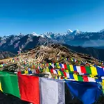
Rasuwa: Mountain Panorama Beauty
Credit:outdooractive.com
How can you reach Rasuwa?
Rasuwa can be reached by bus from Kathmandu (the capital) via the Pasang Lhamu highway (H21), with its headquarters (Dhunche) about 120 kilometres (75 miles) away. As of 2013, three VDCs, Thuman, Langtang, and Haku, are still unaffected by some kind of route.
Climate and Geography of Rasuwa district
The district of Rasuwa is classified into seven climatic zones. They are as follows:
- Upper Tropical
- Subtropical
- Temperate
- Subalpine
- Alpine
- Nival
- Transhimalayan
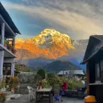
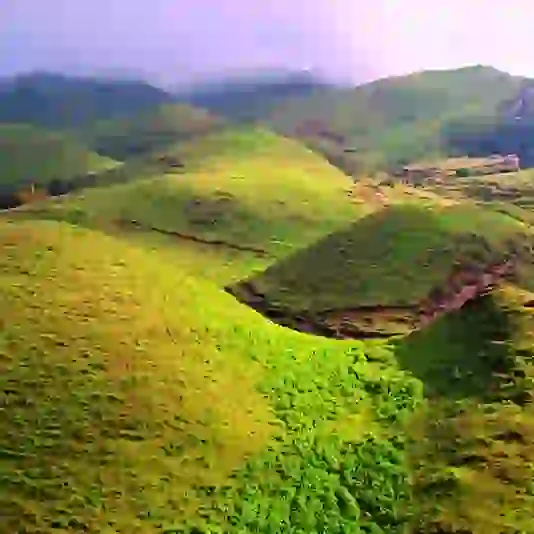
The elevations of its territories range from 614 to 7,227 meters (2,014 to 23,711 feet) above mean sea level. Forests occupy 31.43 per cent of the land, with 16.63 per cent of the land permanently buried in snow. Rasuwa is a popular tourist destination in Nepal because of its steeply varied terrain and abundance of natural blessings.

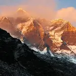
Rasuwa: Peaks Embrace Morning Glow
Credit:jmtreks.com
The district contains tourist attractions such as Gosaikunda Lake and Mt. Langtang and one of Nepal's hot springs (locally known as Tatopani).
Tourism in Rasuwa District
Natural resources abound in Rasuwa. To the north of Rasuwa is the Langtang mountain range. Langtang National Park encompasses a significant portion of the northern part of the area. Rasuwa's tourism highlights include Gosainkunda Lake, Ganja La Pass, and Tamang village in Bridim.
In the Langtang district, the Gosainkunda Lake, also known as "Frozen Lake," is one of the most beautiful mountain lakes. In this region, there are approximately 108 kundas (lakes). The most popular ones are Saraswati Kund, Bhairab Kund, Surya Kund, and Gosainkund.
The Langtang valley, aptly named the valley of glaciers, is another draw in Rasuwa, where mountains climb soaring into the sky. Pine forests, swift mountain streams, rocky granite and snow-capped hills, grassy downs and meadows are strewn with daisies, and wild animals can all be seen in the valley.
Langtang National Park
Langtang National Park, Nepal's first Himalayan national park and the country's fourth protected area, was created in 1976. It stretches over an area of 1,710 km2 (660 sq mi) in the Nuwakot, Rasuwa, and Sindhulpalchok Districts of the central Himalayan region, encompassing 26 village communities and exceeding an elevation range of 6,450 m (21,160 ft).
It is connected to Qomolangma National Nature Preserve in Tibet Autonomous Region in the north and east. The eastern and western boundaries, respectively, follow the Bhote Koshi and Trishuli rivers. The southern border is 32 kilometres (20 miles) north of Kathmandu.
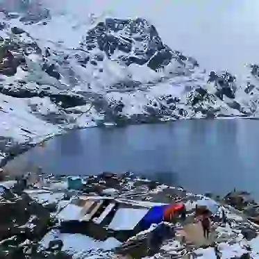
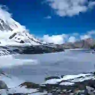
Gosaikunda Lake
Gosaikunda also spelt Gosainkunda and Gosain Kunda, an alpine freshwater oligotrophic lake in Nepal's Langtang National Park 13.8 ha and an elevation of 4,380 m (14,370 ft). It is located at the height of 4,380 m (14,370 ft) in the Rasuwa District (34 acres). The Gosaikunda Lake complex, which includes associated lakes, covers 1,030 ha (4.0 sq mi) and was declared a Ramsar site on September 29, 2007.

Breath Taking the view of Gosaikundha Lake
The Trishuli River is formed as the lake melts; it stays frozen for six months during the winter, from October to June. In the region, there are 108 lakes. On the outskirts is the Lauribina La pass, which rises to 4,610 meters (15,120 feet).
Rasuwa Fort
Rasuwa Fort, also known as Rasuwa Gadhi, is a historical fort ruin in Nepal's Rasuwa District, near the Tibetan border. It is 3 kilometres (1.9 miles) north of the Nepalese town of Timure in Langtang National Park, but 25 kilometres south of the nearest Chinese town of Gyirong Town.
During the second campaign of the Sino-Nepalese War in 1792, the city was the scene of a three-day battle. The fort was built on the site in 1855, during the Rana dynasty, when Jung Bahadur Rana invaded Qing-ruled Tibet in the Nepalese–Tibetan War.
Nepal and China decided in 2012 to open new border crossings, one of which is Rasuwagadhi. In 2013, when building a border crossing, the fort was destroyed. A port of entry was established near the fort in December 2014.
This route between China and Nepal (via Gyirong Town / Kyirong on the Chinese side) was thought to be more secure than the Zhangmu–Kodari crossing.
Tourists can visit the border but not cross the bridge into Tibet with a trekking permit obtained in Kathmandu.
Frequently Asked Questions (FAQs) about Rasuwa District, Nepal
1. What is the climate like in Rasuwa District?
Rasuwa District, Nepal has a temperate climate, with cold winters and mild summers. The temperatures can drop below freezing in winter, especially in higher altitudes, while the summer months (June to August) are generally pleasant with moderate temperatures.
2. What is the weather like in Rasuwa throughout the year?
- Winter (December to February): Cold temperatures with snowfall in higher regions.
- Spring (March to May): Good weather with clear skies, making it the best time for trekking.
- Monsoon (June to August): Heavy rainfall, which can make trekking conditions challenging.
- Autumn (September to November): Ideal weather with clear skies, dry air, and stunning views, making it another best time for trekking.
3. What is the postal code for Rasuwa?
Rasuwa's postal code is 45000.
4. What are some popular trekking destinations in Rasuwa District?
- Langtang Valley: Known for its stunning views, beautiful landscapes, and Tamang culture.
- Gosaikunda Lake: A sacred high-altitude lake surrounded by snow-capped mountains.
- Langtang National Park: Rich in wildlife and natural resources, a great spot for nature lovers.
- Tamang Heritage Trail: A trek through traditional Tamang villages, offering a cultural experience along with scenic views.
5. How far is Kathmandu from Rasuwa?
The distance from Kathmandu to Rasuwa is approximately 120 kilometers (75 miles) by road.
6. How long does it take to travel from Kathmandu to Rasuwa?
The travel time from Kathmandu to Rasuwa depends on road conditions and transportation mode. It usually takes 6 to 7 hours by bus or jeep, but it may take longer during the monsoon season or if the roads are challenging.